Why is it relevant?
Engaging relevant stakeholders is key to running successful Citizen Observatories. A fundamental part of stakeholder engagement is identifying key stakeholders and the larger context in which a Citizen Observatory is (being) embedded in order to know who, why, how and when to engage.
How can this be done?
Deciding which stakeholders are relevant for a Citizen Observatory can be quite complex, especially given that Citizen Observatories are typically linked to (local) issues and policy. Moreover, stakeholders from the same category, e.g. citizens, can play distinctly different roles in an observatory, e.g. as initiator, core community member or observer only and need to be engaged accordingly.
It is therefore important to carefully map the context of the issue and the key stakeholders in order to navigate these. Simple context and stakeholder mapping is a generic approach that is being used in many project-related contexts. It can help to identify and specify the social, economic, environmental and political setting of the observatory as well as the roles, relationships and agendas of different actors.
Context mapping and stakeholder mapping has been tailored and adapted to Citizen Observatories, given that Citizen Observatory characteristics add layers of complexity, for example by cutting across different environmental, political and administrative boundaries. The Ground Truth 2.0 context and stakeholder mapping approach captures relevant information for Citizen Observatories through team discussions or interview questions and combines this in a consolidated context and stakeholder map.
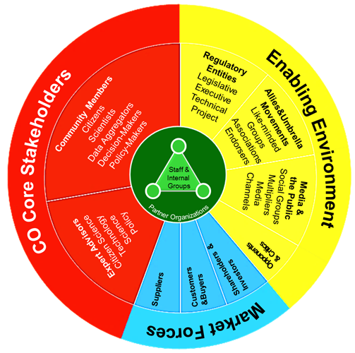
Stakeholder analysis for Citizen Observatories – Example from the Ground Truth 2.0 project
Source: Pfeiffer et al., 2016
The Ground Truth 2.0 project developed a generic stakeholder analysis for Citizen Observatories. This was applied in six countries (four in Europe, two in Africa), and the results identified ten main stakeholder categories. Stakeholders are deliberately listed as having more than one role (i.e., are placed in several categories), indicating potential role conflicts or the need to engage the same stakeholder for multiple reasons. Core stakeholders in any Citizen Observatory are citizens, scientists, (commercial) data aggregators, decision-makers and policy-makers. The ‘enabling environment’ category consists of stakeholders who either have a legal mandate or live in the project area. They influence how the activities of the Citizen Observatory are received, thereby enabling or limiting the impacts that the observatory can achieve. In contrast to the core stakeholders, the enabling environment can influence but cannot be chosen by the Citizen Observatory. ‘Market forces’ consist of those stakeholder groups that engage in direct economic (financial) transactions with the Citizen Observatory. Internal stakeholders (i.e. often partner organisations in a funded project, see inner circle) are important functional entities in the project or organisation. Typically, these are staff and managers of organisations, not all of whom are necessarily in favour of the observatory. This approach to stakeholder analysis can be applied in various geographical contexts and social settings and can be used with different types of issues.
Useful Resources
PROJECT REPORTS: These Ground Truth 2.0 reports explain the context and stakeholder mapping approach, including the adapted PESTEL. They present the findings of the baseline context and stakeholder mapping per case in Africa and Europe as well as the subsequent updated analysis one year into the project.
SCIENTIFIC PAPERS: The Ground Truth 2.0 project produced this conceptual framework for context, process and impact analysis and applied it in two of the Ground Truth 2.0 Citizen Observatories, one in the Netherlands and one in Kenya to create a baseline.
CoP: The WeObserve Co-design & Engage Community of Practice brings together practitioners of Citizen Observatories and citizen science to share and learn different ways of engaging stakeholders in Citizen Observatories.
You may also be interested in:
I want to engage stakeholders…
This work by parties of the WeObserve consortium is licensed under a Creative Commons Attribution-ShareAlike 4.0 International License. ![]()