Why is it relevant?
Applying open data policies to Citizen Observatories increases the impact of the data by preventing ‘data silos’ (storage of different data in different places) and thereby duplication of efforts. Adopting data standards lowers the technical barriers and opens new possibilities for exploiting the data by combining them with other themes and across locations.
How can this be achieved?
There are a range of tools and guidelines that can help your Citizen Observatory apply open data policies and data standards.
A report by the Joint Research Centre of the European Commission from 2018 titled “An inventory of citizen science activities for environmental policies” identified 503 projects in the environment field, and Citizen Observatories are becoming more and more prevalent (more about the history of Citizen Observatories here). As the number of Citizen Observatories and citizen science projects increase, the need for standard practices has become even more critical. The Open Geospatial Consortium (OGC) and the WeObserve project are working on developing best practices on how to apply existing OGC standards for citizen science (see box below).
In parallel, several efforts have been undertaken by administrations and cartographic (mapping) agencies to set and use standard formats and services. This has resulted in the proliferation of Spatial Data Infrastructures (e.g. INSPIRE). The smart cities phenomenon is also possible thanks to the adoption of standard sensor and communication protocols. Citizen science initiatives each have their own characteristics (e.g. a myriad of data authors and a constant conversation and revision of the observations), but they also share many aspects, such as the geospatial nature of environmental measurements and the use of the same variables and observation types as other approaches (e.g ‘smart cities’ sensors).
Citizen Observatories can adopt and test current standards in their own domains. When they do not fit their purpose, they should be extended and adapted based on discussion towards finding consensus. The set of standards enabling sensor webs are a good starting point, as they focus on individual observations from a well-defined set of variables that are aggregated into data streams.
There is also a need for formal representation of Citizen Observatories as a whole as a key tool in enabling the discovery of data sets, projects and campaigns. It should facilitate knowledge sharing and contribute to current standardisation efforts. The Public Participation in Scientific Research (PPSR) Common Conceptual Model is a starting point in this direction.
Lessons learned from the Ground Truth 2.0 project and the Citizen Science Interoperability experiment.
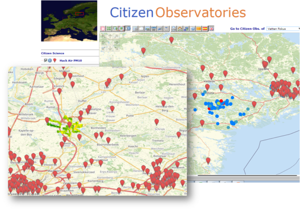
During the Citizen Science Interoperability experiment, the following data servers providing support to the OGC Sensor Observation System (SOS) standard were deployed: MiraMon SOS server, Grow SOS, DLR istSOS SOS, and 52north SOS. Three clients were also produced: MiraMon SOS browser, Grow SOS data viewer, and 52north Helgoland. The group demonstrated interoperability by connecting the SOS clients to the SOS services and showing the data on clients, sometimes mixing data from different services and datasets in a single view.
The illustration presents air quality data from the HachAir project in the DLR premises, together with Ground Truth 2.0 data that uses the MiraMon SOS service.
Useful Resources
TOOL: The Open Data Toolkit is designed to help governments and open data enthusiasts understand the basic concepts of open data, how to plan and implement an open government data programme and some tricks on how to approach a dataset.
WEBSITE: The World Bank page on Starting an Open Data Initiative contains useful information and tools for those looking to take their first steps in an open data initiative.
CHECKLIST: The Open Data Institute page on How to write a good open data policy details the key steps to take in order to understand and develop strong open data practice.
REPORT: The Citizen Science Interoperability Experiment engineering report focuses on the findings of the first phase of the WeObserve and OGC Citizen Science Interoperability Experiment.
REPORT: The report Recommendations on FAIR metrics for EOSC proposes a set of metrics for FAIR data in EOSC to be extensively tested.
BOOK CHAPTER: “A Conceptual Model for Participants and Activities in Citizen Science Projects” in the book “The Science of Citizen Science” provides a conceptual model with which projects and data can be described in a standardised manner.
POLICY: UNESCO is working towards building global consensus on open science via the development of a UNESCO Recommendation on Open Science, which includes Open Data policies.
CoP: The Citizen Science & Open Science Community of Practice, under the umbrella of the Citizen Science Global Partnership, is dedicated to stimulating exchange and cooperation between practitioners from the fields of citizen science and open science
PROJECT REPORT: Engagement activities and their impacts on policy development includes FAO slides from one of the GROW MOOCs covering multi-stakeholder soil governance models.
You may also be interested in:
I want to achieve impact with the Citizen Observatory results…
…by communicating the Citizen Observatory results effectively
This work by parties of the WeObserve consortium is licensed under a Creative Commons Attribution-ShareAlike 4.0 International License. ![]()